Showing posts with label San Lorenzo Valley. Show all posts

Sunday, September 6, 2009

Bridge Idyll

(No, not "idle bridge" -- that would be this one .)

In Henry Cowell Redwoods State Park: part of the railbed of the Santa Cruz, Big Trees & Pacific Railway Company.

There was a very nice, short article about our San Lorenzo River valley in the San Jose Mercury early this summer. It was about a feature that our valley still has that is disappearing from other rivers across America: the swimmin' hole, unfenced, unregulated, un-chlorinated, and probably a little unsanitary, too.

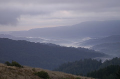
The San Lorenzo River is very short; it runs from the crest of the Santa Cruz Mountains southward to the city of Santa Cruz on Monterey Bay, a distance of less than twenty miles. The whole valley, in fact, can be seen in this photo from a recent SherWords post, from its origin near the bottom of that frame to its outlet in the mid-distance haze. (The smoke plume was from the "Lockheed" wildfire of last month.) Its course runs through a magnificent forest of sequoia sempervirens (coast redwoods) and wends its way through several small towns. A few of those towns dam the stream during the summer to make swimming places for kids (and others) and, especially in its last few miles, there are a number of natural pooling places that require no dammed assistance.

One of those natural pools is in Henry Cowell State Park just south of Felton. (That park was itself a recent topic here in a different context. ) It is in an idyllic place in the park -- if you don't think a railroad excludes the entire concept of "idyll" -- where the river begins its winding path through its final steep canyon to the sea. It is under a hundred-year-old railroad bridge, a bridge that now carries only tourist trains operated twice a day for round trips to the Santa Cruz beach and boardwalk by the Roaring Camp folks.

Shortly after I was finished with summer school in August, I took an early-morning walk with my old Nikon and tripod down the railroad tracks to the bridge. Fog from Monterey Bay still hung at about treetop level in the canyon, lending a muted, diffused light to the redwoods and the forest floor.

The bridge itself posed gracefully for its portraits...

... and I clambered down for a view into the morning's foggy glare downstream:

I resolved to come back at a time when the excursion train was scheduled to cross the bridge, and, after checking the schedule, returned two days later at about 10:30am (after having taken a quick trip to the mountains' crest to snap the above-referenced photo of smoke from the wildfire on Ben Lomond Mountain.)

When I reached the bridge and set up my tripod a little downstream from it, a trio of young girls was already there, enjoying the swimmin' hole under the bridge, taking turns swinging on the long, leisurely rope dangling from the bridge to the water. The photos below, if seen only here, show neither rope nor young girls. If you click on any of the next three photos, though, you should be able to see the long rope near the right-hand bridge pier.

When the train arrived, the girls scuttled, giggling, up the river bank into the woods, but...

... even before the train had completely passed over the bridge, they were back.


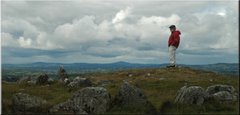
This confluence of things from a different time -- an old railroad bridge, a languid river's swimming spot, a swinging rope's enthrallment -- led me to indulge myself in a bit of Photoshop cuteness that I don't want to let myself do very much. I altered one of my grade-level photos of the bridge to include a different destination on its far side:

A bridge too far.

(You really have to click on the above image to see it larger to get all that I want you to see. Please?)

I think of the strolling figure on the other side, walking with measured strides farther on down the track, as my Dad, who was deeply intrigued by trains and especially their railbeds' courses throughout his life. I am not on the bridge yet, nor (I hope) will be any time soon -- but I can sure see it from here. One of my sons has the good grace to be behind me, out of sight in this picture. The other has broken the rules, has impetuously rushed across the bridge ahead of me, and is already out of sight around the tracks' curve, as was always his way.

As I said, I don't want to let myself do this very much. But there was something about the old bridge, and the morning's fog, and the redwood forest that let me do it this once.

Friday, August 14, 2009

Firetime Again


Today is the second full day of a serious wildfire in our vicinity, the coastal redwood forests of the northern part of Santa Cruz County, California. The fire is large, and largely uncontained at this point, but so far has not taken any lives or structures. Also, while only about four miles from us, geography (it's on the other side of a steep mountain) and prevailing winds are keeping our San Lorenzo Valley from danger.

This time.


Above: a panorama of smoke from the fire, made from five frames. This view is from a vista point along California Highway 9 about halfway along my workaday commute from Boulder Creek to Cupertino. Ft. Harrington is located just a little bit left of the center of the panorama; Monterey Bay and the more distant mountains of Big Sur are at left. If you click on this to see it larger (and I urge that you do!), it will take you to a 2500-pixel wide version that you can scroll around for good detail.

The fire is called the "Lockheed" fire because it is suspected to have started somewhere near a research facility that Lockheed-Martin has atop Ben Lomond Mountain. There is no current suspicion that the facility had anything to do with the fire (and the campus is not in danger from the flames at present), but the folks at Lockheed are probably not happy with the name.

The research facility is near the location of two of my favorite photos:

October, 2005


March, 2006, with a rare dusting of snow


I hope this lovely home of horses has been spared.

[Click here for a short time-lapse movie of smoke billowing over the top of Ben Lomond Mountain.]

=================================================

Saturday, July 18, 2009

Dead Park Walking [UPDATED, July 24]

[Update, July 24:
As Brian notes in the comments, today's action by the State legislature has spared most of the California state parks from closure, if that ever was a serious possibility. Some State parks will almost certainly close, but lists I've seen of the ones on the Governor's plate of possibilities include only those that actually could be physically closed: museums, historical homes, and mines, for example. So it seems that "Kelsey's Park" -- our local Henry Cowell Redwoods -- is likely to remain available to him for at least a while longer.
Now I can get back to the business of worrying about my colleagues' jobs, my students' welfare, my community's ability to function, and the intelligence of my State's leaders.]

=========================================

California isn't just broke, it's broken.

How do you close a forest? How do you close a river?
Kelsey and me, 2001, Henry Cowell State Park


The state is in a state of financial collapse. The legislature and the governor are trying to address a deficit of staggering proportions. The numbers are numbing, and beggar attempts to fathom: currently, the figure is $26 billion dollars for the next year. To try to put that in perspective, it's almost twice the entire yearly expenditure on prisons, and almost half of the entire state annual spending on elementary through community college education, and one-third of its annual expenditures on health and human services. Any fix will involve massive reductions in services, and conjures up images of Dickensian despair among the poor.

Just how the State with the world's eighth-largest economy got itself into this horrid mess can be (and is) debated endlessly, but it all boils down to an initiative process which has written mandatory, large expenditures into the State constitution while also making revenue increases almost impossible. We've been heading toward this gargantuan train wreck for more than thirty years, and it's here.

My own job is in jeopardy, of course, since my salary as a community college teacher ultimately comes from the State's coffers. While the people of my local district have been very, very generous over the past few years, taxing themselves to the tune of half a billion dollars to fund capital improvements (including my incredible new planetarium), that largesse can only go to capital improvements -- it can't fund salaries. My department is in relatively good shape, since we teach huge classes... but the folks at the Titanic's stern were in relatively good shape, too, in the spring of 1912.

Kelsey helps his mistress around the circuit after surgery, Henry Cowell State Park, 2002.

Since crucial state functions like education, safety, and social services are about to fall into an abyss, I almost feel guilty writing what I'm about to. But I'll write it anyway.

Bliss, 2004, Henry Cowell State Park

At last look, California is planning to close 220 of its 279 state parks. This supposedly will save, over a two-year period, about two-tenths of a billion dollars, if one doesn't factor in additional expenses that trying to keep forests and beaches "closed" will entail. Among those 220 are the three parks in our part of the Santa Cruz Mountains: Big Basin (California's first state park with an awe-inspiring stand of thousands of years old Sequoia Sempervirens), Castle Rock at the crest of the mountains, and Henry Cowell Redwoods park in Felton.

That last one is what pierces my heart like a shiv, since it is Kelsey's favorite place in the entire world.

Shortly after we rescued Kelsey from the pound in 1998, we took him for a walk in Henry Cowell park. The joy he manifested on that first visit was thrilling: he didn't walk or run, he leapt from place to place along the path. Sniffing, peeing, pooping, bouncing, grinning... it was like he had found heaven after his puppyhood of neglect. The course we took through he park -- a roughly two-mile circuit through the hardwood forest and along the banks of the San Lorenzo river -- burned itself into his brain then, and he and I have followed that course countless times since.

A winter's walk, 2006, Henry Cowell State Park. Our friend Lucile jollies Kelsey, while Diane is tended by the spaniels.

On most of those trips along his circuit, it has been just him and me, and we traipse it a couple of times a month. Now eleven years old, he can tell when I'm even thinking about taking him to "Kelsey's Park," and his usual dour demeanor changes to giddiness. He will remain patient in the back seat as we drive, until we go past the turn that would take us to the vet, and then he begins trembling. As we turn in to the road to the park entrance, he whines a warble that he never does at any other time, and when we get out of the car, he becomes ecstatic. For a while. Then he becomes all business, sniffing every leaf along our well-known path, marking his specific spots until both tanks are empty, and even beyond that. He wades in the river for about a minute along the way, pauses respectfully when horses pass on the horse-trail part of our circuit, and ignores, for the most part, other people and dogs. He has business to do, you know, and doggy newspapers to read on the scents of the grasses and the leaves.

From a horseback vantage point, 2000, Henry Cowell State Park.

River dog, 2005, Henry Cowell State Park.

If and when the park is closed, I suppose we will find other places for special times -- but, at his advanced age, he will lose something that has been an integral part of his joy forever.

And so will I.

Closure of the parks pales so much compared to other losses that will befall this State that I can't bring myself to become too active in protesting them. Many of the poorest among us are about to be handed a slow-motion death sentence, not by lethal injection but by lethal abandonment. My students, for many of whom community colleges are the last, best hope not just for them but for their families, will lose that opportunity. My co-workers will lose their jobs. How dare I worry about what effect it will have on my dog?

I don't know. You try explaining it to him here in the evening twilight of his life. I can't.

His heaven.

==================================================

Saturday, July 4, 2009

Independence A


This old Model A is a bit like the rest of California on this Fourth of July, 2009: a little run down, a little corroded, but still proud of her looks... and fashionably attired.

I hope you all had a fine day, no matter where you live!

(Photo taken in the Santa Cruz Mountains town of Felton, California.)

Friday, December 26, 2008

A Surprising Tree in a Place Where Trees Don't Surprise

This is the San Lorenzo Valley in California's Santa Cruz Mountains:

San Lorenzo Valley Rain

The trees you can see from this vista point along California Highway 9 are almost entirely sequoia sempervirens, coastal redwoods, and their magnificent height and abundance hides thousands of homes -- including Ft. Harrington, which is roughly in the center of this frame -- from view.

The view from this place a hundred years ago would have been very different. After the great San Francisco earthquake and fire of 1906 (which actually devastated most of the Bay Area, not just San Francisco), this land was almost entirely clear-cut to provide building materials for the great reconstruction. That means that essentially all of the trees you see in the above photo are juveniles in the reckoning of redwoods, only about a century old. Between 1920 and about 1960, as the second-growth redwoods were growing up, the shorter trees of the blanketing forest allowed some things to exist profitably that are now long gone: many swimming pools behind dams in creeks (because shorter trees allowed more sunlight to reach the ground) and even an airport (which is now the Boulder Creek Country Club's golf course), for example.

Part of a poster for the long-gone Boulder Creek drive-in movie theater from half a century ago -- when the re-growing forest was only about half as high as it is now. Two things that were snuffed out by the forest's re-growth are evident in its map: the airport and a big swimming pool. (Click on the image for a higher-resolution view.) Poster courtesy of Jeff Liebermann. Note that apostrophe abuse is not a new phenomenon.

Many of the trees in the photo at the top of this entry, when seen up close, are members of tight, circular groups. One such group is on the Ft. Harrington grounds:

The summer furniture and patio occupy the footprint of the surrounding redwoods' ancestor, the ancient giant that lives on in its offshoots.

The circle of trees in these groups are sprouts, or "suckers", from the roots of a truly ancient, mammoth, primordial redwood, which may have been thousands of years old when felled. The scale of our patio in this photo shows the trunk size of the ancestral giant. All of our neighbors in "Creepy Hollow" have at least one such circle of sprouts, and those sprouts themselves now are more than a hundred feet tall.

Hundred-foot tall trees, while they may be "juvenile," can still be a problem to those who live underneath them if they are not cared for. Redwoods tend to shed limbs as part of their growing process. Trouble is, the limbs they shed are typically as big as full-grown pine trees in other climes. (Adam, I'm sure, remembers very well how impressive such shed limbs can be when they hit the ground -- he was visiting during a winter storm in the first year or two of our living here when several of them shook the earth. The previous occupant of this place neglected her trees' care.) It's wise to have weakened limbs removed before they break off on their own. Intentionally-removed redwood limbs are called "maintenance expenses;" spontaneous fallers are called "widow-makers."

There are two different ways of thinning potential widow-makers that local arborists tend to use: selective thinning and "columnization."


The above photo shows three circles of second-growth redwoods: the one on our property whose base was shown above (left), one on our thoroughly irresponsible neighbors' property (center), and one on a good neighbor's property (right). Ours is pretty much indistinguishable from the reprobates' cluster, because our tree-caretaker's philosophy is to take only those limbs that pose a danger. His (and our) preference is to leave the trees looking as much like they naturally would as possible, and thus the appearance of our trees is pretty much like neglected ones'.

The right-hand clump shows the other way of caring for them: just shave everything up to the point where you'd better leave needles for survival. Our tree guy snortingly calls this approach "columnization," and, until two weeks ago, I never would have thought that this particular neighbor would go for that look.

But she did. Two weeks ago. Before that, her trees looked pretty much like ours.

I didn't ask her about it, because the opportunity never arose in passing, and, besides, that's the kind of thing we tend to leave each other alone about here in Creepy Hollow.

On Christmas Eve, Diane and I drove up to Pleasant Hill, a couple of hours away, to celebrate the holiday with Grace-the-Granddaughter, Adam, Adrianne, and a whole gaggle of the clan. We didn't get back until well after dark... and were then well and truly treated to what our neighbor had in mind when she had her trees "columnized." The next day, Christmas day, I took a series of photos from late afternoon to dark, that shows her plot:

A Neighbor's Christmas Tree (1 of 5)
Afternoon.

A Neighbor's Christmas Tree (3 of 5)
Evening.

A Neighbor's Christmas Tree (5 of 5)
Night.

What a HOOT! It's like suddenly having an illuminated Washington Monument plunked down in your little hollow! The lights extend well over a hundred feet up the tree (I know; I used a high-precision Fies Protractor for the measurement computations) and are visible throughout the neighborhood. She says that next year she may have the remaining, high-altitude branches festooned with lights, too, and I hope she does. Then it would be a hundred-foot arrow of lights pointing straight UP.

Meanwhile, the Ft. Harrington Christmas Tree was of much more modest scale:

Christmas in Ft. Harrington, 2008
More about Christmas will be posted here soon, but Christmas isn't really over yet. I'll leave you now with how Emma looked yesterday while presents were being opened:

TOO. MUCH. FUN.

Please click on the above images for higher-resolution versions, especially the ones of our neighbor's tree.

Thursday, November 27, 2008

Tanksgiving, 2008 [Updated on Dec. 6]

About a week ago, I posted this picture to PicShers, the photo-a-day family snapshots blog:

It shows the intersection of California highways 236 and 9 in Boulder Creek, and was taken on November 19th, 2000. Even last week, the 2000 price of gas looked quaintly low.

This picture was taken a couple of hours ago, from about the same spot:

The gas station has changed companies, and the price board isn't quite so bold about its contents, but if you look closer...

... you'll see that the price per gallon of regular is now three cents less than it was eight years ago.

While that's nice in an obvious way, it's also unsettling. I may just be Joe the Astronomer, not Tito the Economist, but even I can figure out that when the price of such a crucial commodity as gasoline goes through precipitous swings -- in either direction -- it's probably an indicator of a sick economy.

On the bright side, though, I filled the Jeep's tank for less than 30 bucks, and the guy across the street by Johnnie's Market was having a great time with his dog.

Update, December 6, nine days later: the price is down to $1.769. That's a decline of more than two cents a day. At this rate, clearly not sustainable, we'll be down to the magic price of 45 cents a gallon in two months. (That's a "magic price" because, at that point, gas itself is essentially free, since 45 cents per gallon here is for various taxes, so the price per gallon cannot go below that.) This isn't a price fall, it's a collapse. Weird.