 In Adrianne's garden.
Several of the regular readers of this irregular blog posted articles celebrating Independence Day on July 4th: Mike did, Ruth did, Dann did, and even ronnie posted a wish for us from north of the unstressed border.
Selfish lizard that I am, though, I didn't. Instead, I chose to indulge myself by enjoying some of the benefits that ultimately came tumbling out of the events of 232 years ago. I spent the day taking a long, leisurely drive around the beautiful area I live in, the land around San Francisco Bay, and enjoying a gathering of the extended clan at Adrianne and Grace's house for a great barbeque. Thanks, Declaration signatories (and all the others who, through the years, have furthered and defended their vision); I enjoyed on that day the stuff you started. The only downer was that Diane couldn't accompany me, since she was still not feeling completely up to snuff after a little accident she had a few weeks ago.
Here's a top-down map of my wanderings (click the map to see a version you can actually read):
 The light blue trail is my path to Adrianne and Grace's place in Pleasant Hill, while the purple one traces my return. The numbered spots indicate locations from which the photos below were taken. I tried to avoid freeways as much as practicable, given time constraints. If I was going to pay almost fifty bucks in gasoline for the roughly 200-mile round trip, I sure as shootin' was going to enjoy the ride.
Fair warning: what follows, especially the long section at the barbeque, will be of interest only to family, if them. But others are, of course, welcome to join us in virtuality!
The Ride Up to Pleasant Hill
Here's a perspective view, courtesy of Google Earth, from the Boulder Creek end:
 (The termini of the routes marked are the centers of the towns, not our actual home locations. I'm not that unconcerned about putting such personal details out here on the web-o-sphere.)
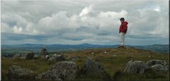
Photo position 1, from a vista point parking lot along California route 35, also known as "Skyline":

 Looking eastward. My destination today, Pleasant Hill, is beyond -- but not a whole lot beyond -- the most distant band of clouds (whose slight brown tint is due to smoke from the Big Sur fire, far to the south on the coast.) The water is San Francisco Bay, and the white patches are salt evaporators.
Photo position 2, in an old section of the town of Fremont in the East Bay:

This photo was taken specifically for, and in homage to, the world-famous Canadian blogging cat, Mojo, who is somehow under the impression that he is the President of Cuba.
I have no idea where that idea came from. Really. I don't.
 Niles Canyon provides a narrow slot through which a single-track rail line and a two-lane highway find a shortcut from the Livermore area through the East Bay hills down to the heavily populated flatlands by the Bay.
 Palomares Road is a scenic ten-mile byway through the heart of the hills that generally parallel two busy Interstate highways: 880 along the East Bay's flatlands and 680 on the east side of the East Bay hills. I discovered it in October, 1989, when I was living in Oakland. The Loma Prieta earthquake of that month devastated normal transportation routes around the Bay for months after, and I used this road as part of an inventive-by-necessity daily commute from Oakland to Cupertino and back.
 View to the east from Palomares Road.
 Adrianne shows off the first season of her raised-bed vegetable garden!
 Grace has become quite the swimmer: she's great at diving down to the bottom of the pool and retrieving the weighted rings. It is so very hard to adapt to the fact that she'll be six years old next month. By the time I do, she'll probably be seven. And then 15.
 Grace's cousin, Kiana, and her aunt (and Adam's sister), Reva.
 Grace and Kiana in the pool.
 We had very special visitors from England at this celebration of separation therefrom: Adam's uncle John, the younger (but not youngest) brother of Adam's late mother, and his wife, Ngoc Thu. John, recently retired from a long and successful career at Reuters, is a naturalized British citizen. I had only seen him once in the past 40 years, and that one time was more than 20 years ago. I was delighted at how the years fell away with grace and ease. John is the fellow in the blue shirt; the guy in red is Bill Lombardo, who was a great friend of Doug's. Bill is a musician from, yes, that Lombardo family: Guy was his uncle.
 John and Ngoc Thu live in the south of London most of the time, but they have a new second home near Lyon, France. Ngoc Thu is in dark blue, above. Adrianne, in green at right, is famously petite, but notice that Ngoc Thu is standing on a step, and, even then, is only a little taller than Adrianne. Like Adrianne, though, she packs a very large personality in a very small package.
 Grace's step-granddad, Adam's stepfather, Reva's father, Kiana's grandfather, Parris, was there with his wife, Dierdre. They live in Grass Valley, California, now, which is where Diane's parents lived after her dad retired. It strikes me that some sort of diagram of this family's relationships to one another might be interesting. Or maybe even form the basis for a doctoral dissertation in sociology.


Uncle Adam and Kiana.
Through his voiceover career connections, Adam hooked Kiana and Reva up with an agent who now has Kiana doing professional photo modeling. I am not kidding; that's real.
 "Sometimes my uncle is just so silly that it's beyond words. Rully, it is."
 Adam and Lynda.
If you can, zoom in on the right lens of Adam's sunglasses (the left one, of course, from our perspective here.) You'll see a very proud father in the act of taking a snapshot of two wonderful people.
 Adrianne's mom's dog, Jack, and I hit it off very well. He knows a sucker for small dogs -- or just a sucker, period -- when he sees one.
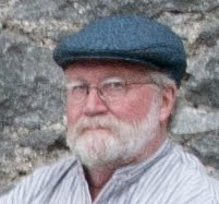
 Gramps heads out (photo by Adam.)
 Google Earth perspective view of the trip home (the purple trail, at left.)
Photo position 4:
 The trip back involved a ride down the length of Niles Canyon, starting in the village of Sunol (and its old-timey but functioning train station) at the top.
Sunol had its Warhol-McCluhan quarter hour of fame in the early 1980's, when its citizens sagely elected a black labrador retriever, Bosco, to be their mayor. The Chinese were famously not amused. According to this 1990 article in the New York Times:
Photo position 5 (you'll have to go back to the first map to see this location; it's very nearly all the way back home in Boulder Creek):
 Fog drifting into the San Lorenzo Valley.
The Jeep rattled home, over the Saratoga Gap on Highway 9, past this vista point (which we elegantly call "pee point" because of its handy latrine) at nearly sundown, with the Pacific's natural air conditioner flowing into the valleys of the redwoods. It had been a very good day, with the notable exception of the absence of my girlfriend.
And the absence of my older son. You didn't think you'd get through this entire post without mention of him, did you? Not yet, no, not yet.
Thank you, gentlemen below. I couldn't have done it without you.

=======================================
I have no idea where that idea came from. Really. I don't.
Photo position 3, on Palomares Road, just off its intersection with Niles Canyon Road:
 Niles Canyon provides a narrow slot through which a single-track rail line and a two-lane highway find a shortcut from the Livermore area through the East Bay hills down to the heavily populated flatlands by the Bay.
 Palomares Road is a scenic ten-mile byway through the heart of the hills that generally parallel two busy Interstate highways: 880 along the East Bay's flatlands and 680 on the east side of the East Bay hills. I discovered it in October, 1989, when I was living in Oakland. The Loma Prieta earthquake of that month devastated normal transportation routes around the Bay for months after, and I used this road as part of an inventive-by-necessity daily commute from Oakland to Cupertino and back.
 View to the east from Palomares Road.
At the Barbeque
 Adrianne shows off the first season of her raised-bed vegetable garden!
 Grace has become quite the swimmer: she's great at diving down to the bottom of the pool and retrieving the weighted rings. It is so very hard to adapt to the fact that she'll be six years old next month. By the time I do, she'll probably be seven. And then 15.
 Grace's cousin, Kiana, and her aunt (and Adam's sister), Reva.
 Grace and Kiana in the pool.
 We had very special visitors from England at this celebration of separation therefrom: Adam's uncle John, the younger (but not youngest) brother of Adam's late mother, and his wife, Ngoc Thu. John, recently retired from a long and successful career at Reuters, is a naturalized British citizen. I had only seen him once in the past 40 years, and that one time was more than 20 years ago. I was delighted at how the years fell away with grace and ease. John is the fellow in the blue shirt; the guy in red is Bill Lombardo, who was a great friend of Doug's. Bill is a musician from, yes, that Lombardo family: Guy was his uncle.
 John and Ngoc Thu live in the south of London most of the time, but they have a new second home near Lyon, France. Ngoc Thu is in dark blue, above. Adrianne, in green at right, is famously petite, but notice that Ngoc Thu is standing on a step, and, even then, is only a little taller than Adrianne. Like Adrianne, though, she packs a very large personality in a very small package.
 Grace's step-granddad, Adam's stepfather, Reva's father, Kiana's grandfather, Parris, was there with his wife, Dierdre. They live in Grass Valley, California, now, which is where Diane's parents lived after her dad retired. It strikes me that some sort of diagram of this family's relationships to one another might be interesting. Or maybe even form the basis for a doctoral dissertation in sociology.

Uncle Adam and Kiana.
Through his voiceover career connections, Adam hooked Kiana and Reva up with an agent who now has Kiana doing professional photo modeling. I am not kidding; that's real.
 "Sometimes my uncle is just so silly that it's beyond words. Rully, it is."
 Adam and Lynda.
If you can, zoom in on the right lens of Adam's sunglasses (the left one, of course, from our perspective here.) You'll see a very proud father in the act of taking a snapshot of two wonderful people.
 Adrianne's mom's dog, Jack, and I hit it off very well. He knows a sucker for small dogs -- or just a sucker, period -- when he sees one.
The Trip Home
 Gramps heads out (photo by Adam.)
 Google Earth perspective view of the trip home (the purple trail, at left.)
Photo position 4:
 The trip back involved a ride down the length of Niles Canyon, starting in the village of Sunol (and its old-timey but functioning train station) at the top.
Sunol had its Warhol-McCluhan quarter hour of fame in the early 1980's, when its citizens sagely elected a black labrador retriever, Bosco, to be their mayor. The Chinese were famously not amused. According to this 1990 article in the New York Times:
One of the more unusual attacks on the United States came in February in a sarcastic front-page article in People's Daily and other newspapers, asserting that the idiocy of American democracy could be seen in the election of a dog as mayor of a California town called Sunol.
''Western democracy has reached such a pinnacle that there is democracy not only among human beings, but also with dogs,'' the newspaper crowed. It added that the election ''is a wake-up tonic for those kindhearted people who blindly worship Western democracy out of ignorance and naivete.''
Bosco, they hardly knew ye.Photo position 5 (you'll have to go back to the first map to see this location; it's very nearly all the way back home in Boulder Creek):
 Fog drifting into the San Lorenzo Valley.
The Jeep rattled home, over the Saratoga Gap on Highway 9, past this vista point (which we elegantly call "pee point" because of its handy latrine) at nearly sundown, with the Pacific's natural air conditioner flowing into the valleys of the redwoods. It had been a very good day, with the notable exception of the absence of my girlfriend.
And the absence of my older son. You didn't think you'd get through this entire post without mention of him, did you? Not yet, no, not yet.
Thank you, gentlemen below. I couldn't have done it without you.

=======================================
8 comments:
This is just an outstanding post, Sherwood. So much good stuff packed in. I never think to use Google earth in my travel posts, but it adds so much!
To be honest with you, the thought that a diagram of your family relationships would be a fascinating study has occurred to me more than once while reading your blog. You truly are a modern American family in the best sense of the term.
Husband and I were highly amused by 'teh Mojo Lounge' and especially the headliner but the Commandante hasn't seen it yet. But he will - he will. And how he will interpret it... well, Bast only knows.
Ditto what ronnie said - geographical context enhances the experience of terrific photos. I thought it was very nifty in your Ireland posts, and I recall that Mike also used either google earth or another map to show us a drive, in a post quite awhile ago. Yall have a good idea there. Next time i go somewhere more interesting than Costco 8~) , i might be tempted to try it.
Good to see so much blue smoke-free sky, and may it remain so, but sorry Diane was feeling low. Please extend my wishes to her for a speedy and thorough recovery.
Wow...a great post, indeed! So very colorful and enjoyable.
I had no idea that we were but one stop on such an ambitious walkabout (or driveabout). GREAT photos. Kiana's "well I never!" in particular.
Adam-
p.s. surely you noticed the last name of the first performer listed on the schedule board at the Mojo Lounge.....
many thanks for your very kind comment on X.E. your blog is a feast!
Well done, Sherwood. I wish I'd had more time to explore that area when I was out that way a while back.
Thanks, all, for your kind words.
ronnie and Ruth, what frustrates me about using Google Earth in my posts is that I do it so infrequently that I have to learn all over again how to put stuff on an image and save it. I know that's an issue on my side of my eyeballs, but I'd rather blame Google for it. Vicki, over at Oddprofessor recently used something called the "Gmaps Pedometer" to do a similar thing with a kayak outing. I'll have to look into that as an option.
Mary Ellen, right back atcha with the kind words thanks. I think what I'm proudest of with this post is that it evidently earned me a place on Xtreme English's blogroll. What an honor! And as for the last name of the performer on the Mojo Lounge marquee, that was the thing that actually made me turn around after a bit and go back to take the picture. I see that el Jefe him-very-self has now taken note of it over on i am mojo.
Dann, I'm sorry that you didn't make it up this way, too! But you were in the Los Angeles area, right? That would have been a major side trip.
And Adam... hey, you're anonymous again! The barbeque wasn't just one stop, it was the reason for the trip. Actually, that whole backroads, wandering, roundabout route only took about 45 minutes longer each way than the quickest freeway route between Boulder Creek and Pleasant Hill. With gas prices the way they are, I'd just as soon look at driving as entertainment whenever possible, and that extra hour and a half -- for the same price -- was as good as a movie for me. Worth the price.
I was a little further north. Lodi. Right about the time y'all had a whale stuck upstream.
As things turned out, I had long days on both of the days I was out there. It was all I could do to get some garlic squid from the local Chinese food emporium and bathe in the air conditioning at the end of the day.
Some day I'll get the pics from the Sacremento airport on my blog. Pretty neat place.
Post a Comment