Day 30 of 35: Thursday, September 2, 2010
 Uisneach Denizens
This was to be our last true vacation day headquartered in the Bothy; Friday, our actual last full day, would be taken up mostly with packing to leave early the following morning. Today broke with clear skies and a light mist on the ground.
 Two-panel panorama of the Bothy in the early light of September 2nd.
After I took a brief trip to the library and its internet connection, we set out for the Hill of Uisneach near Mullingar, said to be the ancient center of Ireland.
 Along the way, we took an unplanned detour to see the southernmost tip of Lough Ennell through which the River Brosna flows (Mullingar is at the northern end.) The lake appears to be a great recreation asset for the local people, well away from tourist attractions and, of course, beautiful.
 This area at the lake is called “Lilliput,” because of Jonathan Swift’s connection to the region: he frequently retreated to this area in general and this lake in particular to gain solitude for writing. A sign near the shore at this place provides a map of the Mullingar region for bicyclists and reads:
It’s time to take things slowly… Quiet country roads with stunning views of rich pastureland and beautiful lakes provide the ideal backdrop for your cycle routes. Enjoy some fresh air, peace and tranquility. Mullingar is your starting point. A busy market town with excellent facilities and amenities, Mullingar is finely situated on the River Brosna near the ancient centre of Ireland. Visit the beautiful Renaissance style Catholic Cathedral and admire breath-taking frescoes. Visit the local tourist office at the Market Square and see the statue of the late Joe Dolan, commemorating the life and music of Mullingar’s own and internationally renowned singer and entertainer. Venture north to Lough Owel and on to Multyfarnham with it’s [sic] 13th Century Franciscan Friary. Follow in the steps of ancient Irish warriors on the Táin Trail and cycle alongside the Royal Canal, built in the 1800s, and now a recreation amenity and wildlife haven. Cycle south around Lough Ennell, relax at Lilliput amenity area and visit the 18th Century estate at Belvedere where bike parking facilities are available. Whichever route you choose you will enjoy a pleasant cycle in a gentle landscape rich in lake and canal, lore and legend.I’m sold, but I have no bicycle.
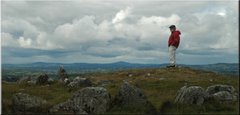
From the lake, we backtracked to our original destination, the Hill of Uisneach (pronounced “Oosh’-nuk”.)
The hill is not on public land, or administered by the OPW. It is on a working farm, and permission to enter should be obtained from the owner. The farmhand who gave us our map of the hill (left over from a Mayday celebration there, an annual New Age spiritual gathering called "the Festival of the Fires" at the traditional center of Ireland) also gave rather ambiguous directions for the easiest walk to the top. Against Diane’s better inclinations, she followed her husband on what turned out to be a very circuitous and rather arduous trudge through pastureland up the 600 feet or so of vertical relief. Not bad for someone on a bum ankle.
 Clockwise from upper-left: Parking area and sign on the R390 road west of Mullingar, Diane trudging, more Diane trudging, and curious cows.
 The summit features a variety of recent structures, mostly wicker – and an incredibly stunning 360° vista to the far reaches of Ireland. From that point, it is easy to understand why this place has been special in a number of ways for thousands of years.
==================================
More images from September 2nd, including a very large, 360° panorama of the view from the top of the Hill of Uisneach, are available in this slideshow on sharrington.net.
==================================
More images from September 2nd, including a very large, 360° panorama of the view from the top of the Hill of Uisneach, are available in this slideshow on sharrington.net.
==================================
Next: September 3, 2010 -- Last Full Day in Birr
Previous: September 1, 2010 -- A Midlands Ramble
Beginning of the series: Prologue, August 2
Previous: September 1, 2010 -- A Midlands Ramble
Beginning of the series: Prologue, August 2
No comments:
Post a Comment