Harringtons' Ireland Pictures of the Day, Part 1
This marks the 1-year anniversary of the start of Diane's and my 2006 trip to Ireland.Each day for the next month, I'll post two (or, at most, three) pictures from the corresponding day a year ago from our huge collection of images. I'll try to include one "scenery," long-range shot and one of more small-scale detail in each day's offerings, but that may not always (or even frequently) be possible.
Rather than have 30+ individual blog posts, I'll update this one (at the bottom) each day for a while and see how long it takes until it becomes unwieldy.
=========================================================
July 26 - 27
Leavin' on a Jet Plane
Our airline travel began with a short flight from San Francisco to Los Angeles. A pleasant surprise at the outset of that flight was that we traveled over the Santa Cruz Mountains on a path that put our home in easy view out our window on the right side of the plane:
 Looking down toward the southwest over the San Lorenzo Valley, Santa Cruz Mountains.
Details from that view:

Left: the town of Boulder Creek. The long, straight street is Highway 9 through town.
Right: at the center of this detail, about 2 1/2 miles North of town and hidden by the trees' canopy, is Fort Harrington.
In LAX, we caught an Aer Lingus nonstop to Dublin.
 Our home in the sky for ten hours from Los Angeles to Dublin.
Traveling through eight time zones in that direction meant that we arrived in Ireland about midday on the 27th, jetlagged, sleepless, and with a case of excited jitters. All we did on the 27th was to check in to our hotel at the airport and bathe, eat, and sleep, sleep, sleep, charging our batteries for the 28th -- so there are no pictures from the 27th.
July 26 - 27
Leavin' on a Jet Plane
Our airline travel began with a short flight from San Francisco to Los Angeles. A pleasant surprise at the outset of that flight was that we traveled over the Santa Cruz Mountains on a path that put our home in easy view out our window on the right side of the plane:
 Looking down toward the southwest over the San Lorenzo Valley, Santa Cruz Mountains.
Details from that view:

Left: the town of Boulder Creek. The long, straight street is Highway 9 through town.
Right: at the center of this detail,
 about 2 1/2 miles North of town and hidden by the trees' canopy, is Fort Harrington.
In LAX, we caught an Aer Lingus nonstop to Dublin.
 Our home in the sky for ten hours from Los Angeles to Dublin.
Traveling through eight time zones in that direction meant that we arrived in Ireland about midday on the 27th, jetlagged, sleepless, and with a case of excited jitters. All we did on the 27th was to check in to our hotel at the airport and bathe, eat, and sleep, sleep, sleep, charging our batteries for the 28th -- so there are no pictures from the 27th.
====================================================
July 28th: Near Dublin
 Lighthouse at Howth harbour near Dublin.
 On the shore of the Irish Sea, looking toward Wales.
Click here to be taken to a 14-slide show with captions from July 26 - 28, 2006.
====================================================
July 29th: to Birr
 The Bothy, Birr Castle Demesne

... and a private green door to the formal gardens area. This is the Bothy's little west lawn, and the other side of the door to the gardens is pretty well hidden from view of the daily tourists. After 6pm, the Demesne closed its doors for day visitors, and the wonderland beyond that green secret door was ours virtually alone to enjoy until the late summer twilight ended well past nine.
====================================================
July 30th: Birr Castle Demesne
 The brick bridge over the Little Brosna, Birr Castle Demesne.
We spent the day of Sunday, July 30th, settling in to our new home for the next four weeks: unpacking, checking out the town's stores, and so on. We also spent a good deal of time checking out the magnificent parkland of the Demesne, especially after six when the outer gates closed and we were pretty much the only people wandering about the grounds. We came to view the old brick bridge as a symbol of the Demesne; it is ancient (by American standards, anyway), is near the centre of the Demesne, and it crosses a doubly-noteworthy boundary, the Little Brosna river just downstream from its juction with the Camcor within the Demesne. Where the bridge crosses the river, it is the boundary between the counties of Offaly and Tipperary ("counties" having roughly the same function in Ireland as states do in the US) and between the provinces of Leinster and Munster.
 Miss Kitty
This day was dedicated to getting used to driving on the "wrong" side of the road (and of the car) before we set out on our drive to our midlands home for the next month. We thought that the town of Howth (pronounced "Hohth," or, more usually with the Irish dialect's treatment of the thorn, "Hoht") looked like it would be a comfortable drive for starters.
It also turned out to be a gorgeous introduction to Ireland.
It also turned out to be a gorgeous introduction to Ireland.
 Lighthouse at Howth harbour near Dublin.
 On the shore of the Irish Sea, looking toward Wales.
Click here to be taken to a 14-slide show with captions from July 26 - 28, 2006.
====================================================
July 29th: to Birr
By Saturday, July 29th, we were ready to drive to our home for the next four weeks: a cottage called "The Bothy" on the grounds of the Birr Castle Demesne in the town of Birr (formerly Parsonstown) in County Offaly (formerly King's County), right smack dab in the middle of Ireland. The drive wasn't a long one by American standards, less than a hundred miles and under three hours.
Birr and its castle had caught my attention years and years ago for an astronomical reason: the 72-inch "Leviathan of Parsonstown" was the largest telescope in the world from 1843 until it fell into disuse and rot in the early 20th Century (see this entry in my blog for more information.)
In early 2001, while idly browsing the web, I found that the Castle had a couple of cottages that they rent out on a weekly basis. Ultimately, that led to our reserving this absolute gem of a place for four weeks in 2006:
 The Bothy, Birr Castle Demesne
The Bothy (pronounced "BAH-thee"), a three-bedroom cottage, was built in the mid-1800's as staff accomodation. It is in an out-of-the-way corner of the Demesne's 135-acre grounds, private, quiet, and enchanting. It is in an interesting little interstitial space between two ten-foot-high stone walls, which were built around the Demesne in the famine years as a works relief project for the citizens of the town (not as real castle defenses.) Off-frame to the right in the above view is the Demesne's outer wall, directly beyond which is a street, and directly on the street's other side is the home of the fellow who drives Birr's ice cream vending truck during the summer. He'd come home at about seven o'clock most nights, and he'd play his truck's music in a burst as he arrived home. That was just one of the sounds we learned to expect and enjoy from the tranquil town just beyond our castle walls.
Off-frame to the left in the above view is the Demesne's inner wall...
Off-frame to the left in the above view is the Demesne's inner wall...

... and a private green door to the formal gardens area. This is the Bothy's little west lawn, and the other side of the door to the gardens is pretty well hidden from view of the daily tourists. After 6pm, the Demesne closed its doors for day visitors, and the wonderland beyond that green secret door was ours virtually alone to enjoy until the late summer twilight ended well past nine.
July 30th: Birr Castle Demesne
 The brick bridge over the Little Brosna, Birr Castle Demesne.
We spent the day of Sunday, July 30th, settling in to our new home for the next four weeks: unpacking, checking out the town's stores, and so on. We also spent a good deal of time checking out the magnificent parkland of the Demesne, especially after six when the outer gates closed and we were pretty much the only people wandering about the grounds. We came to view the old brick bridge as a symbol of the Demesne; it is ancient (by American standards, anyway), is near the centre of the Demesne, and it crosses a doubly-noteworthy boundary, the Little Brosna river just downstream from its juction with the Camcor within the Demesne. Where the bridge crosses the river, it is the boundary between the counties of Offaly and Tipperary ("counties" having roughly the same function in Ireland as states do in the US) and between the provinces of Leinster and Munster.
 Miss Kitty
This day we were also introduced to our companion for the next month: Miss Kitty, the Bothy Cat. Many regular readers of this blog are already familiar with her, thanks to this very nice cite in ronniecat's blog, but newcomers might want to take a look at this slideshow, devoted to our great, unexpected Irish treasure.
====================================================
July 31st: the Slieve Bloom Mountains
July 31st: the Slieve Bloom Mountains
Monday the 31st was a dank and drizzly day, but we did take a few hours out of our settling-in and reconnoitering of the town of Birr to take a leisurely drive through the Slieve Bloom Mountains, just to Birr's southeast.
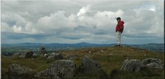
 Looking northward from near the highest point of the Slieve Blooms. Stretching off into the misty distance are the rich farmlands of the valley of the River Shannon, the heart of the Irish midlands.
Like many other parts of the until-recently nearly denuded island, the Slieve Blooms have been intensely re-forested. To our eyes, though, the method of reforestation was not exactly pleasing to the eye: fast-growing pines planted in rigid ranks and files. Later we would find that our host in the Birr Castle Demesne, Lord Rosse, who has done reforestation consulting work in third world countries for the UN, shares not only our aesthetic assessment, but thinks the choice of wood and blatant disregard for erosion control issues are even worse blunders on the part of the government.
 Diane walks a trail through the reforestation.
The rank-and-file pine forests reminded me strongly of the reforested areas of Upstate New York, where I grew up. In fact, the above picture of Diane could have been taken on a truck trail in the Whaupaunaucau State Forest across the Thompson Creek valley from my boyhood home. Except for the steering wheel being on the wrong side of the car, of course.
Click here to be taken to a 24-slide show, with captions, of images taken from July 29th through 31st.
I'll start a new post for the first week in August tomorrow.
====================================================
8 comments:
If, say, a hypothetical reader happened to really want to steal a picture for he- his or her own desktop or slideshow, and not for any commercial purpose -- say, hypothetically speaking, that beautiful one of the boats in Howth harbor -- would s- he or she hear from your lawyer? Or, scarier, Oolie's lawyer?
8~)
I would be flattered! Go right ahead. If you'd like a higher-resolution one, the originals are 3000x2000 pixels and about 2.5 megabytes -- I'd be happy to send or post on the website (temporarily) one(s) if you'd like.
I can't speak for Oolie's lawyer. Thank God.
I'd love a high rez version! Any way that's easiest. No rush.
Thanks!
Here you go, Ruth:
http://sharrington.net/HowthHarb.jpg
It's about 2.5 megs, as advertized, and I'll take it down in a few days to conserve space on the server. Let me know by e-mail when you've snagged it.
A nice trip for those of us too tied down to travel in three-dimensions!
Hooray! Bothy cat!
(Oh, and the other stuff is very nice, too ;) )
Hi. I'm from France, and I had a big journey in Irland in May last year. I was in the Stieve Bloom mountains, but I can't remember exactly which was the way I drived in. Perhaps could you help me, because you have a photo looking down to the flat land that seems to be taken from the same place as one of mine. Looking to my photos on http://www.allersretours.com/index.php?page=euro2008_019, could you help me to find exactly the place where they were taken (I speak only for these about Slieve Bloom mountains, of course. And bravo for your blog! Thanks in advance for helping. Jef from France (atwin at allersretours dot com)
Hi, Jef!
I sent you a reply by e-mail. If you didn't receive it, let me know, and I'll post it here.
Post a Comment