Harringtons' Ireland Pictures of the Day, Part 5
[This is part 5 of a one-year-later photo remembrance of our trip to Ireland last summer. Each day for about the next week, a new day's entry will be added to the bottom of this entry.]
==========================================
Monday, August 21
The Ring of Kerry
We set out on this morning for a leisurely drive around the perimeter of County Kerry's Iveragh Peninsula, a loop known as "The Ring of Kerry," and justly famous for its spectacular scenery. This being August, the height of the tourist season, and the Ring being one of Ireland's premier attractions, we expected the roads and the stops to be crowded, and they were. Diane doesn't mind crowds as much as this blogger does, and she's very good at schmoozing, especially with people who have animals (click on any image to see a larger, higher-resolution version):
 Diane at a roadside vendors' location, happily talking to a man with three donkeys. (She went on to the the woman with the dog behind her after buying some goodies from the donkey guy.)
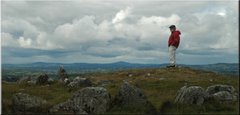
We traveled the Ring in the customary counter-clockwise direction, starting out along the northern edge of the peninsula. The views were, of course, delightful whichever way we turned, either inward toward the mountainous interior (toward McGillicuddy's Reeks)...
 Toward McGillicuddy's Reeks from the north shore of the Iveragh Peninsula
... or outward across Dingle Bay.
 Dingle Bay from the Iveragh side (the mountains of the Dingle Peninsula can be seen in the distance.)
At the far end of the peninsula is the Coomakista Pass, just south of the village of Waterville. Again, a place for grand vistas in either direction, either back north toward Waterville...
 Looking north from the Coomakista Pass: Waterville and Ballinskelligs Bay
... or south toward the broad mouth of the Kenmare River.
 Looking south from the Coomakista Pass: Derrynane Bay and the Caha Mountains of the Beara Peninsula in the distance.
The above two pictures were taken from a good way up the side of a steep hill near the pass's carpark. Here's the view from my perch directly down on the parking lot:
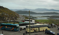 Coaches at Coomakista.
As we poked and plodded our way around the Ring, we encountered these same coaches and their people many times. Our favorite was the group in the short green coach (only the roof of which can be seen in this image): a group of schoolgirls from New Zealand, obviously having the time of their lives. We even encountered them at the out-of-the-way Cahergall Stone Fort across a river from Caherciveen, and their exuberance lent yet another layer of joy to the experience. (Slides including the stone fort will be linked in tomorrow's post.)
We spent the late afternoon poking along the southern side of the Iveragh Peninsula, as far as the village of Sneem, and then backtracked to the Peninsula's far west end and the Derrynane Hotel, where we were scheduled to spend two nights.
 Twilight near Derrynane and Caherdaniel.
 Diane at a roadside vendors' location, happily talking to a man with three donkeys. (She went on to the the woman with the dog behind her after buying some goodies from the donkey guy.)
We traveled the Ring in the customary counter-clockwise direction, starting out along the northern edge of the peninsula. The views were, of course, delightful whichever way we turned, either inward toward the mountainous interior (toward McGillicuddy's Reeks)...
 Toward McGillicuddy's Reeks from the north shore of the Iveragh Peninsula
... or outward across Dingle Bay.
 Dingle Bay from the Iveragh side (the mountains of the Dingle Peninsula can be seen in the distance.)
At the far end of the peninsula is the Coomakista Pass, just south of the village of Waterville. Again, a place for grand vistas in either direction, either back north toward Waterville...
 Looking north from the Coomakista Pass: Waterville and Ballinskelligs Bay
... or south toward the broad mouth of the Kenmare River.
 Looking south from the Coomakista Pass: Derrynane Bay and the Caha Mountains of the Beara Peninsula in the distance.
The above two pictures were taken from a good way up the side of a steep hill near the pass's carpark. Here's the view from my perch directly down on the parking lot:
 Coaches at Coomakista.
As we poked and plodded our way around the Ring, we encountered these same coaches and their people many times. Our favorite was the group in the short green coach (only the roof of which can be seen in this image): a group of schoolgirls from New Zealand, obviously having the time of their lives. We even encountered them at the out-of-the-way Cahergall Stone Fort across a river from Caherciveen, and their exuberance lent yet another layer of joy to the experience. (Slides including the stone fort will be linked in tomorrow's post.)
We spent the late afternoon poking along the southern side of the Iveragh Peninsula, as far as the village of Sneem, and then backtracked to the Peninsula's far west end and the Derrynane Hotel, where we were scheduled to spend two nights.
 Twilight near Derrynane and Caherdaniel.
==========================================
Tuesday, August 22
Limping "Home"
 The Derrynane Hotel
The hotel was a major disappointment. While the top floor with its restaurant, lounges, and bar was nice, the residential floors looked and felt like cell blocks: painted concrete-block wall hallways, cheap bare fluorescent tube lighting in those halls, and long, long walks to rooms with no convenient parking. The room itself (on the other side from this picture, against the hillside with no view) was hardly decorated at all, and had no provision for making coffee or tea in the room, something we have become very accustomed to. The place wasn’t run down or dirty, and staff were competent and friendly, but it just wasn’t a great place.
Moreover, Diane’s surgically-repaired ankle flared up painfully swollen on this morning, making any hiking out of the question. So, all in all, we decided to scrap our planned investigation of the interior of the Iveragh peninsula, our trip to the Dingle Peninsula, and our second night at this hotel and drive back to our cozy Bothy home inside the castle walls instead. The plan at this point was to try to see if rest would get Diane's ankle in good enough shape to enjoy our final three days in Ireland -- the upcoming Friday, Saturday, and Sunday -- in Dublin.
 Kenmare
We stopped in the lovely town of Kenmare on our way home to visit a shop we had learned offered beautiful pieces of traditional Irish lace. We obtained some lovely items there, to be gifts to some of our friends on our return to California.
 Moll's Gap
Our drive back to Birr from Kenmare took us over the summit of Moll's Gap and back through Kenmare. Some of the grand scenery from Moll's Gap can be seen in these three dozen slides with captions.
 Miss Kitty
On our return, the Bothy Cat greeted us warmly. We miss her.
==========================================
Wednesday, August 23
Hunkered Down
 A showery day. Click on the image to see a much larger one, in which you can see water droplets on the cables of this old wooden bridge across the Camcor.
While poor Diane rested her ankle, I strolled around the Demesne through occasional showers (camera protected by a plastic bag from Super Valu) taking the last few shots I needed to finish the Red Tree Trail project. The pictures I needed were mostly of foliage on tall trees, so I had the long-focus lens on the camera on this day. That provided some interesting perspectives on now-familiar places.
 A stone face in the Theatro Verde, seen from under a sheltering tree during a shower.
 Lily pads and raindrops near Inis Dara and the fernery.
 The 1927 log cabin.
I could imagine a young Brendan Parsons playing in that cabin on just such a rainy day many decades ago, perhaps with his older half-brother. Sometimes a cabin is better than a castle.
==========================================
Wednesday, August 24
Last Full Day in the Midlands
This day, our last full day in the Birr environs, we took a short trip up to Tullamore to visit the "Tullamore Dew Heritage Centre" just for a quick outing and, maybe, to get Adam a wee giftie.
 Ireland's Grand Canal wanders through Tullamore.
 The Tullamore Dew Heritage Centre abuts the canal (at left), a prime transport avenue for the distillery's raw materials and products in the 1800's.
Tullamore hooch is now actually manufactured elsewhere, and the old factory and warehouse was refurbished in the 1990's (with the ubiquitous help of EU money). The site is now a combination museum/bar/restaurant/3-D advertisement.


Two wax figures in the museum.
That was a very short trip. Most of the day we prepared for tomorrow's departure and continued to try to rest Diane's ankle (without much -- any, in fact -- improvement.) Curiously, we didn't see the Bothy Cat at all today (or the next). The last time we saw her was on Tuesday, the 23rd, when she was in the company of a big ginger tabby. When we first saw her, four weeks ago, she was with that cat, too... and we never saw him in between. I'm sure there's a charming story in there somewhere.
==========================================
Friday, August 25
Back to Dublin
 The caption for this photo in our trip diary is, simply, "Sigh."
Above is our last picture from the Birr Castle Demesne. Our little blue rental car is packed, Diane is in the passenger seat, and all I have to do now is close the Bothy's front door, slam the trunk, and get in the right side of the car (in both senses of "right") and we'll be on our way.
The Bothy was more than a wonderful place to stay. After four weeks, it was home.
On our way out of town, we stopped in the back parking lot of the Super Valu grocery store for a little bit of last-minute shopping: a cane for Diane and a teddy bear sporting County Offaly colours for... me. Maybe I'll share a picture someday, maybe I won't.
 Potato Speakeasy?
I took the opportunity to take this picture of an old warehouse and mill building at the back of the parking lot. On the building's other side is a back street called Mill Street (which you'll have an opportunity to ride along in a video in the final HI-POD installment in just a few days.) On the Mill Street side of the building is a steel door with a hand-lettered sign that simply said "NEW POTATOES." We frequently saw people buying large sacks of potatoes from there.
As cosmopolitan as Ireland has become, especially (we're told) under the double-influences of its modern prosperity and of its membership in the EU, potatoes still dominate the country's food in a big way. At dinner, even in very upscale restaurants, it's not unusual to have three different potato dishes: a side bowl of small boiled potatoes drizzled in herbed butter, a baked potato, and a bed of mashed potatoes under the entree.
French fries, by the way, are now more often called "fries" than "chips" -- we even had a waiter in Clifden rather sternly correct us when we ordered "chips." If that seems an unusual thing for a stereotypical Irishman to do, it probably would be. It wasn't at all unusual for a typical waiter or waitress to do in Ireland, though, since most of them we encountered on this trip were eastern European, primarily Polish (but the Clifden guy was Russian.) Polish immigration is a significant phenomenon in Ireland. With its strong economy and small population, there is no shortage of demand for people willing to do what are viewed as the more menial jobs. Larger grocery stores have Polish food sections.
The drive from Birr to the outskirts of Dublin was uneventful, but...
 M7 Crawl.
... a couple of miles from the ring road on the M7, we slowed to this crawl, a stop-and-go condition that persisted all the way to our hotel, the same one at the airport that we had stayed in at the beginning of our trip four weeks and an age ago. It took us two hours to get to Dublin from Birr, but then another two and a half hours to get from the point of the above picture to our hotel.
We spent the evening pondering what we should do for our last two days. Our plan had been to spend this Friday evening in Dublin, wandering, reconnoitering, and enjoying -- but that was out. If Diane's ankle somehow miraculously healed overnight, we would spend Saturday strolling Dublin, visiting the tourists' highlights plus the Post Office and Croke Park, and in the evening join a pub crawl. (Please click on both links; I think they will help explain why missing them would be a sad thing for us -- of course, why the pub crawl would be a sad thing to miss needs no explanation.) If the ankle turns out to be as bad or worse than it was on this day, we'd use our car to explore County Wicklow.
Wicklow won.
==========================================
Saturday, August 26
County Wicklow
==========================================
Sunday, August 27
Newgrange and the Hill of Tara
==========================================
Tomorrow -- HI-POD: Part 6
Conclusion
==========================================
Tuesday, August 22
Limping "Home"

The hotel was a major disappointment. While the top floor with its restaurant, lounges, and bar was nice, the residential floors looked and felt like cell blocks: painted concrete-block wall hallways, cheap bare fluorescent tube lighting in those halls, and long, long walks to rooms with no convenient parking. The room itself (on the other side from this picture, against the hillside with no view) was hardly decorated at all, and had no provision for making coffee or tea in the room, something we have become very accustomed to. The place wasn’t run down or dirty, and staff were competent and friendly, but it just wasn’t a great place.
Moreover, Diane’s surgically-repaired ankle flared up painfully swollen on this morning, making any hiking out of the question. So, all in all, we decided to scrap our planned investigation of the interior of the Iveragh peninsula, our trip to the Dingle Peninsula, and our second night at this hotel and drive back to our cozy Bothy home inside the castle walls instead. The plan at this point was to try to see if rest would get Diane's ankle in good enough shape to enjoy our final three days in Ireland -- the upcoming Friday, Saturday, and Sunday -- in Dublin.
 Kenmare
We stopped in the lovely town of Kenmare on our way home to visit a shop we had learned offered beautiful pieces of traditional Irish lace. We obtained some lovely items there, to be gifts to some of our friends on our return to California.
 Moll's Gap
Our drive back to Birr from Kenmare took us over the summit of Moll's Gap and back through Kenmare. Some of the grand scenery from Moll's Gap can be seen in these three dozen slides with captions.
 Miss Kitty
On our return, the Bothy Cat greeted us warmly. We miss her.
Wednesday, August 23
Hunkered Down
 A showery day. Click on the image to see a much larger one, in which you can see water droplets on the cables of this old wooden bridge across the Camcor.
While poor Diane rested her ankle, I strolled around the Demesne through occasional showers (camera protected by a plastic bag from Super Valu) taking the last few shots I needed to finish the Red Tree Trail project. The pictures I needed were mostly of foliage on tall trees, so I had the long-focus lens on the camera on this day. That provided some interesting perspectives on now-familiar places.
 A stone face in the Theatro Verde, seen from under a sheltering tree during a shower.
 Lily pads and raindrops near Inis Dara and the fernery.
 The 1927 log cabin.
I could imagine a young Brendan Parsons playing in that cabin on just such a rainy day many decades ago, perhaps with his older half-brother. Sometimes a cabin is better than a castle.
==========================================
Wednesday, August 24
Last Full Day in the Midlands
This day, our last full day in the Birr environs, we took a short trip up to Tullamore to visit the "Tullamore Dew Heritage Centre" just for a quick outing and, maybe, to get Adam a wee giftie.
 Ireland's Grand Canal wanders through Tullamore.
 The Tullamore Dew Heritage Centre abuts the canal (at left), a prime transport avenue for the distillery's raw materials and products in the 1800's.
Tullamore hooch is now actually manufactured elsewhere, and the old factory and warehouse was refurbished in the 1990's (with the ubiquitous help of EU money). The site is now a combination museum/bar/restaurant/3-D advertisement.


Two wax figures in the museum.
That was a very short trip. Most of the day we prepared for tomorrow's departure and continued to try to rest Diane's ankle (without much -- any, in fact -- improvement.) Curiously, we didn't see the Bothy Cat at all today (or the next). The last time we saw her was on Tuesday, the 23rd, when she was in the company of a big ginger tabby. When we first saw her, four weeks ago, she was with that cat, too... and we never saw him in between. I'm sure there's a charming story in there somewhere.
==========================================
Friday, August 25
Back to Dublin
 The caption for this photo in our trip diary is, simply, "Sigh."
Above is our last picture from the Birr Castle Demesne. Our little blue rental car is packed, Diane is in the passenger seat, and all I have to do now is close the Bothy's front door, slam the trunk, and get in the right side of the car (in both senses of "right") and we'll be on our way.
The Bothy was more than a wonderful place to stay. After four weeks, it was home.
On our way out of town, we stopped in the back parking lot of the Super Valu grocery store for a little bit of last-minute shopping: a cane for Diane and a teddy bear sporting County Offaly colours for... me. Maybe I'll share a picture someday, maybe I won't.
 Potato Speakeasy?
I took the opportunity to take this picture of an old warehouse and mill building at the back of the parking lot. On the building's other side is a back street called Mill Street (which you'll have an opportunity to ride along in a video in the final HI-POD installment in just a few days.) On the Mill Street side of the building is a steel door with a hand-lettered sign that simply said "NEW POTATOES." We frequently saw people buying large sacks of potatoes from there.
As cosmopolitan as Ireland has become, especially (we're told) under the double-influences of its modern prosperity and of its membership in the EU, potatoes still dominate the country's food in a big way. At dinner, even in very upscale restaurants, it's not unusual to have three different potato dishes: a side bowl of small boiled potatoes drizzled in herbed butter, a baked potato, and a bed of mashed potatoes under the entree.
French fries, by the way, are now more often called "fries" than "chips" -- we even had a waiter in Clifden rather sternly correct us when we ordered "chips." If that seems an unusual thing for a stereotypical Irishman to do, it probably would be. It wasn't at all unusual for a typical waiter or waitress to do in Ireland, though, since most of them we encountered on this trip were eastern European, primarily Polish (but the Clifden guy was Russian.) Polish immigration is a significant phenomenon in Ireland. With its strong economy and small population, there is no shortage of demand for people willing to do what are viewed as the more menial jobs. Larger grocery stores have Polish food sections.
The drive from Birr to the outskirts of Dublin was uneventful, but...
 M7 Crawl.
... a couple of miles from the ring road on the M7, we slowed to this crawl, a stop-and-go condition that persisted all the way to our hotel, the same one at the airport that we had stayed in at the beginning of our trip four weeks and an age ago. It took us two hours to get to Dublin from Birr, but then another two and a half hours to get from the point of the above picture to our hotel.
We spent the evening pondering what we should do for our last two days. Our plan had been to spend this Friday evening in Dublin, wandering, reconnoitering, and enjoying -- but that was out. If Diane's ankle somehow miraculously healed overnight, we would spend Saturday strolling Dublin, visiting the tourists' highlights plus the Post Office and Croke Park, and in the evening join a pub crawl. (Please click on both links; I think they will help explain why missing them would be a sad thing for us -- of course, why the pub crawl would be a sad thing to miss needs no explanation.) If the ankle turns out to be as bad or worse than it was on this day, we'd use our car to explore County Wicklow.
Wicklow won.
Saturday, August 26
County Wicklow
As consolation prizes go, this loop through the high country of the southeast would be hard to beat. The countryside was quite different in character than any we had seen before, and the long history of relative wealth and cultivation lent a more domesticated appearance to the fields of Wicklow than of, say, Mayo or even Tipperary.
This day's loop took us south of Dublin to Bray, the Powerscourt Falls, and Glendalough, and then generally northwestward through the Wicklow Gap and back to Dublin. As usual, we found many places to use back roads rather than more heavily-traveled thoroughfares, and were richly rewarded, visually, for the effort.
Just a few of our sights:
 Powerscourt Falls, a popular weekend picnic spot for Dubliners.
 County Wicklow high country.
 Near Roundwood, the "highest village in Ireland," according to our Frommer's guide. Clicking the above image will yield a much larger image than usual, just to preserve enough resolution for you to be able to pick out the bird against the clouds' dramatic backdrop.
 Heather and a cold, clear stream near the Wicklow Gap summit.
 Click on the back road for a dozen slides of sights along our Wicklow wander:
This day's loop took us south of Dublin to Bray, the Powerscourt Falls, and Glendalough, and then generally northwestward through the Wicklow Gap and back to Dublin. As usual, we found many places to use back roads rather than more heavily-traveled thoroughfares, and were richly rewarded, visually, for the effort.
Just a few of our sights:
 Powerscourt Falls, a popular weekend picnic spot for Dubliners.
 County Wicklow high country.
 Near Roundwood, the "highest village in Ireland," according to our Frommer's guide. Clicking the above image will yield a much larger image than usual, just to preserve enough resolution for you to be able to pick out the bird against the clouds' dramatic backdrop.
 Heather and a cold, clear stream near the Wicklow Gap summit.Click on the back road for a dozen slides of sights along our Wicklow wander:
==========================================
Sunday, August 27
Newgrange and the Hill of Tara
On this day, our last full day in Ireland, we traveled north from Dublin to visit the Boyne Valley passage tombs and the Hill of Tara. Diane insisted that we go, because she had long wanted to visit Tara's hilltop and because she figured she had at least a little bit of walking left in her ankle until it became intolerable.
Unlike Loughcrew and Carrowmore, the megalithic site at Newgrange is elaborately set up for tourism. It sports a very well-designed visitors' centre (with a wealth of explanatory exhibits, multi-media presentations in several languages, and the usual tourist amenities) which, from the outside, blends in so well with the countryside as to be almost invisible.
 Spire of the suspension pedestrian bridge across the Boyne from the Interpretive Centre to the bus stop to the tombs.
 View Northwestward up the River Boyne from the suspension bridge.
Buses ferry people in small groups from the suspension bridge to the three main tomb sites: unreconstructed Knowth and Dowth and the reconstructed Newgrange tumulus. Figuring that we should only attempt one, we opted for the famous Newgrange reconstruction.
 Modern pilgrims approach the tomb entrance at Newgrange.
The passage tomb itself inside the mound is still original, and we were guided into it in small groups. (Unlike on our private-by-happenstance tour at Loughcrew, however, we weren't allowed to take pictures inside the Newgrange tomb.)
 At right is a small opening, about a yard across, above the entrance to the passage tomb. Called the "roof box," it allows sunlight to penetrate all the way to the back chamber, about 30 yards away, on the five days around the winter solstice. Newgrange is the only passage tomb in Ireland with such a structure.
After a very pleasant and informative second visit to the Interpretive Centre, we drove the short hour or so along back roads to the Hill of Tara, in legend the home of Ireland's ancient kings and, in actuality, the site of Ireland's spiritual center from about 4,000 BC to the time of St. Patrick.
 Tara has a wealth of archaeological relics -- and, on this last Sunday of the high tourist season, it had a wealth of tourists, too, as the jammed parking area at left attests. The area itself is so large -- and so awe-inspiring -- that we didn't feel crowded, though.

Right: an interpretive sign at the Hill of Tara. You really should click on it to make the short printed introduction legible.
 Diane at the Assembly Mound and Cormac's House ruins on Tara's summit.
 Tourists atop Tara as our last afternoon in Ireland turns blustery.
 St. Patrick has a statue on the Hill of Tara; genu-click it to be taken to fifteen slides of our day at Newgrange and Tara:
From Tara, we wandered back southward, along rural byways through horse country, back to Swords, and on to our hotel at the airport. I returned our faithful steed, the little blue rental car, walked back to the hotel from the rent-a-car place, and we pouted for a while before packing for tomorrow's journey.
Unlike Loughcrew and Carrowmore, the megalithic site at Newgrange is elaborately set up for tourism. It sports a very well-designed visitors' centre (with a wealth of explanatory exhibits, multi-media presentations in several languages, and the usual tourist amenities) which, from the outside, blends in so well with the countryside as to be almost invisible.
 Spire of the suspension pedestrian bridge across the Boyne from the Interpretive Centre to the bus stop to the tombs.
 View Northwestward up the River Boyne from the suspension bridge.
Buses ferry people in small groups from the suspension bridge to the three main tomb sites: unreconstructed Knowth and Dowth and the reconstructed Newgrange tumulus. Figuring that we should only attempt one, we opted for the famous Newgrange reconstruction.
 Modern pilgrims approach the tomb entrance at Newgrange.
The passage tomb itself inside the mound is still original, and we were guided into it in small groups. (Unlike on our private-by-happenstance tour at Loughcrew, however, we weren't allowed to take pictures inside the Newgrange tomb.)
 At right is a small opening, about a yard across, above the entrance to the passage tomb. Called the "roof box," it allows sunlight to penetrate all the way to the back chamber, about 30 yards away, on the five days around the winter solstice. Newgrange is the only passage tomb in Ireland with such a structure.
After a very pleasant and informative second visit to the Interpretive Centre, we drove the short hour or so along back roads to the Hill of Tara, in legend the home of Ireland's ancient kings and, in actuality, the site of Ireland's spiritual center from about 4,000 BC to the time of St. Patrick.
 Tara has a wealth of archaeological relics -- and, on this last Sunday of the high tourist season, it had a wealth of tourists, too, as the jammed parking area at left attests. The area itself is so large -- and so awe-inspiring -- that we didn't feel crowded, though.
Right: an interpretive sign at the Hill of Tara. You really should click on it to make the short printed introduction legible.
 Diane at the Assembly Mound and Cormac's House ruins on Tara's summit.
 Tourists atop Tara as our last afternoon in Ireland turns blustery.St. Patrick has a statue on the Hill of Tara; genu-click it to be taken to fifteen slides of our day at Newgrange and Tara:
From Tara, we wandered back southward, along rural byways through horse country, back to Swords, and on to our hotel at the airport. I returned our faithful steed, the little blue rental car, walked back to the hotel from the rent-a-car place, and we pouted for a while before packing for tomorrow's journey.
==========================================
Tomorrow -- HI-POD: Part 6
Conclusion
==========================================
1 comment:
Your articles are inventive. I am looking forward to reading the plethora of articles that you have linked here. Thumbs up!
Hi pod
Post a Comment